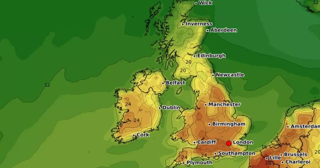
Brits are set for balmy conditions next week with the mercury rising to 28C and you can find out here how warm it will reach in your area.
We have had a week of sunshine and showers in the UK where low pressure systems have moved in to bring some rain while temperatures have remained generally pleasant in the mid to high teens. And it will be a similar theme going into the weekend but by Sunday and the mercury will begin to ratchet up as a high pressure system begins to dominate. According to the latest forecasts, Brits can expect heatwave temperatures of 25C and above from Tuesday.
“There is another warm spell on the way, temperatures will be building to well above the seasonal average,” said BBC weather forecaster Elizabeth Rizzini. “Why? Well because we are drawing in a southerly wind and that warmer air moving in from the near continent and it is going to be widespread so all four national will see temperatures in the low 20Cs at least, maybe the mid 20Cs for some, maybe 27C on Wednesday for southeast England. Well above the seasonal average which is just 12C to 15C.”
Maps from WXCharts show the warmest areas being in the north and north east next Tuesday where it could reach 24C and then the following day Wednesday, April 30 it remains similarly hot in the north while the south and south east sees the mercury rise. Going into the Thursday and the charts predict a wider area of hot weather with most of England in the mid 20Cs with the mercury highest in the south.
And then for Friday a map shows the temperature rising to 28C in London and the southeast at around midday, while by 6pm the hottest area will have moved to the northwest of England and onto the border with Wales where it will again be 28C. The Met Office is also predicting temperatures in midweek rising to 27C “quite widely”, most likely in London, Berkshire, Hampshire, and possibly Kent and East Anglia.
Grahame Madge, a Met Office spokesperson, said: “This would always have been a naturally warm spell. However, with the footprint of climate change, you can expect it to add a degree or so to the values that we would have expected.
“So, it’s likely that the temperatures for this event will be slightly higher. At the moment, it looks as though we’re probably not going to see heatwave conditions met.”
According to the Met Office, the definition of a heatwave is three consecutive days of temperatures exceeding the “heatwave threshold”, which varies across the country.
The threshold is 25C for most of the UK, with slightly higher numbers for the south and east, and rising to 28C in London. Mr Madge said any chance of a heatwave depends on the progress of a cold front which is expected to move south.
“Now, as that front moves south, it will be pulling in cooler air behind it. Not cold air, but cooler air,” he said. “That will clip temperatures. So, there’s a lot of emphasis on when this cold front will start to move and how much progress it will make during Thursday.”
Before that dry and sunny conditions are expected for the thousands taking part in the TCS London Marathon on Sunday, with highs of 22C forecast for the capital.
At Reach and across our entities we and our partners use information collected through cookies and other identifiers from your device to improve experience on our site, analyse how it is used and to show personalised advertising. You can opt out of the sale or sharing of your data, at any time clicking the “Do Not Sell or Share my Data” button at the bottom of the webpage. Please note that your preferences are browser specific. Use of our website and any of our services represents your acceptance of the use of cookies and consent to the practices described in our Privacy Notice and Cookie Notice.

